Noefra: Difference between revisions
Admiralbenbo (talk | contribs) No edit summary |
Admiralbenbo (talk | contribs) mNo edit summary |
||
| (2 intermediate revisions by the same user not shown) | |||
| Line 2: | Line 2: | ||
== Political Map == | == Political Map == | ||
The image displays the political borders of Noefra as of | The image displays the political borders of Noefra as of 253 AC. Capitals are marked as black dots; white dots represent significant secondary cities (secondary capitals, for instance). Nations are named in white text; areas without overlays are populated by scattered groups without a cohesive government (usually nomadic or pastoral tribes that do not claim persistent territory). Most of the continent (other than the [[Northern Frostlands]]) are inhabited, but civilization and organized nations remain few and far between except in the central parts of the western side and the far east. The entire south-east portion, marked "Here there be dragons" is the [[Dragonreach]], which is home to various flights of [[dragons]], but they've asked me not to mark their territory. And as I do not wish to be eaten, I have complied. The far-eastern [[Zhanryu Island]] is marked with "Monsters" because truly, those are the rulers. Strange and terrible beasts found no where else, all of whom are hostile to outsiders...and each other. | ||
[[File:Noefra-253AC-political.webp|none|thumb|800x800px]] | |||
Nations Marked: | |||
[[File:Noefra | * [[Khaimal]] | ||
* [[Auringon]] | |||
* [[Tlalocana]] | |||
* [[Wyrmhold]] | |||
* [[Byssia]] | |||
* [[Crisial Kingdom]] | |||
* [[Horse Clans|Seraaja]] | |||
* [[Duarchy of Kotimaa]] | |||
* [[Windwalker Confederacy]] | |||
* [[True Hold]] | |||
* [[Rauviz]] | |||
* [[Holy Kaelthian Republic]] (HKR) | |||
* [[Sha'slar Autonomous Zone]] | |||
* [[Asai'ka (Nation)|Asai'ka]] | |||
* [[Serpent Dominion]] | |||
* [[Tarad'am]] | |||
* [[Oldhome]] | |||
* [[Uulan Confederacy]] (aka [[Fuar Uulan]]) | |||
* [[Shinevog]] | |||
* [[Bel's Kush]] | |||
* [[Rol'tor Free State]] | |||
* [[Shaadval]] | |||
* [[Ocieli]] | |||
* [[Shaanti]] | |||
* [[Jinse Empire]] | |||
* [[Abandoned Clans]] | |||
* [[Tuura Adam]] | |||
* [[Abantu]] | |||
* [[Nirda]] | |||
== Geographic Regions == | |||
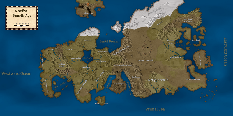
[[File:Noefra geographic.webp|frameless|800x800px]] | |||
West to east, north to south: | |||
* [[Frozen Coast]] | |||
* [[Lost Coast]] | |||
* [[Drowned Coast]] | |||
* [[Nocthian Caldera]] | |||
* [[Gap-tooth Bay]] / [[Byssia]] | |||
* [[Fiach Wood]] | |||
* [[Lupaus Plains]] | |||
* [[Southshore]] | |||
* [[Blood-thirst Wildlands]] | |||
* [[Isle of Fire]] | |||
* [[Kotimaa]] | |||
* [[Lake Coy'in]] | |||
* [[Dreamshore]] | |||
* [[Sea of Grass]] | |||
* [[Jungle of Fangs]] | |||
* [[Sentinel Island]] | |||
* [[Sea of Dreams]] | |||
* [[Giant Spine Mountains]] | |||
* [[Outer Barrier Range]] | |||
* [[Moon's Vengeance]] | |||
* [[Great Eastern Dustlands]] | |||
* [[Dragonreach]] | |||
* [[Northern Frostlands|Northern Frostlands (Northern Waste)]] | |||
* [[Hagfen]] | |||
* [[Shaanti Forest]] | |||
* [[Golden Plains]] | |||
* [[Northern Badlands]] | |||
* [[Nery Forti]] | |||
* [[Zhanryu Island]] | |||
* [[Cerulean Desert]] | |||
Bordering oceans: | |||
* Westward Ocean | |||
* [[Primal Sea]] | |||
* Eastward Ocean | |||
* Frostbound Sea | |||
[[Category:Continents]] | |||
[[Category:Quartus]] | |||
Latest revision as of 03:28, 4 November 2024
The north-eastern continent of Quartus, Noefra is the center of most campaigns to date. It was the site of the Cataclysm War, as well as the original continent from which Oelfra and Soefra were split.
Political Map
The image displays the political borders of Noefra as of 253 AC. Capitals are marked as black dots; white dots represent significant secondary cities (secondary capitals, for instance). Nations are named in white text; areas without overlays are populated by scattered groups without a cohesive government (usually nomadic or pastoral tribes that do not claim persistent territory). Most of the continent (other than the Northern Frostlands) are inhabited, but civilization and organized nations remain few and far between except in the central parts of the western side and the far east. The entire south-east portion, marked "Here there be dragons" is the Dragonreach, which is home to various flights of dragons, but they've asked me not to mark their territory. And as I do not wish to be eaten, I have complied. The far-eastern Zhanryu Island is marked with "Monsters" because truly, those are the rulers. Strange and terrible beasts found no where else, all of whom are hostile to outsiders...and each other.

Nations Marked:
- Khaimal
- Auringon
- Tlalocana
- Wyrmhold
- Byssia
- Crisial Kingdom
- Seraaja
- Duarchy of Kotimaa
- Windwalker Confederacy
- True Hold
- Rauviz
- Holy Kaelthian Republic (HKR)
- Sha'slar Autonomous Zone
- Asai'ka
- Serpent Dominion
- Tarad'am
- Oldhome
- Uulan Confederacy (aka Fuar Uulan)
- Shinevog
- Bel's Kush
- Rol'tor Free State
- Shaadval
- Ocieli
- Shaanti
- Jinse Empire
- Abandoned Clans
- Tuura Adam
- Abantu
- Nirda
Geographic Regions
West to east, north to south:
- Frozen Coast
- Lost Coast
- Drowned Coast
- Nocthian Caldera
- Gap-tooth Bay / Byssia
- Fiach Wood
- Lupaus Plains
- Southshore
- Blood-thirst Wildlands
- Isle of Fire
- Kotimaa
- Lake Coy'in
- Dreamshore
- Sea of Grass
- Jungle of Fangs
- Sentinel Island
- Sea of Dreams
- Giant Spine Mountains
- Outer Barrier Range
- Moon's Vengeance
- Great Eastern Dustlands
- Dragonreach
- Northern Frostlands (Northern Waste)
- Hagfen
- Shaanti Forest
- Golden Plains
- Northern Badlands
- Nery Forti
- Zhanryu Island
- Cerulean Desert
Bordering oceans:
- Westward Ocean
- Primal Sea
- Eastward Ocean
- Frostbound Sea

